NOTICE OF REGULAR MEETING AND PUBLIC HEARING BY THE
CITY COUNCIL OF THE CITY OF CHUBBUCK, IDAHO,
TO CONSIDER THE URBAN RENEWAL PLAN FOR THE
HARVEST SPRINGS URBAN RENEWAL PROJECT
OF THE URBAN RENEWAL AGENCY OF CHUBBUCK, IDAHO, ALSO KNOWN AS CHUBBUCK DEVELOPMENT AUTHORITY
NOTICE IS HEREBY GIVEN that on Wednesday, November 3, 2021, at 6:00 p.m. in the City Council Chambers, Chubbuck City Hall, 290 E Linden Ave, Chubbuck, Idaho, the City Council of the city of Chubbuck, Idaho (“City”) will hold, during its regular meeting, a public hearing to consider for adoption the proposed Urban Renewal Plan for the Harvest Springs Urban Renewal Project (the “Plan”), of the Urban Renewal Agency of the City of Chubbuck, Idaho, also known as Chubbuck Development Authority (“Agency”). The urban renewal and revenue allocation area boundary is hereinafter described. The Plan proposes that the Agency undertake urban renewal projects, including identifying public facilities for funding, pursuant to the Idaho Urban Renewal Law of 1965, Title 50, Chapter 20, Idaho Code, as amended. The Plan being considered for adoption contains a revenue allocation financing provision pursuant to the Local Economic Development Act, Title 50, Chapter 29, Idaho Code, as amended, that will cause property taxes resulting from any increase in equalized assessed valuation in excess of the equalized assessed valuation as shown on the base assessment roll as of January 1, 2021, to be allocated to the Agency for urban renewal purposes. The Agency has adopted and recommended approval of the Plan. Any and all persons may register comments, protests, or agreements on the hearing subjects being considered. Oral testimony concerning these proposals may be offered at the public hearing. Council may limit oral testimony. Written testimony must be received by jbowers@cityofchubbuck.us at least 7 days prior to the hearing, shall comply with standards established in City resolution 2021-06, and shall be considered public record. Following the hearing, the City Council may suspend the rules requiring three complete and separate readings of the Ordinance, and may approve the an Ordinance to approve the Plan. Due to COVID-19 and CDC best practices for social distancing, the public meeting will occur in-person and via web-conference and telephone. Details on how to attend the meeting and participate are found below.
The general scope and objectives of the Plan are:
a. The engineering, design, installation, construction, and/or reconstruction of storm water management infrastructure to support compliance with federal, state, and local regulations for storm water discharge and to support private development. Stormwater projects anticipated within the Project Area are included with projects for public parks or open space, as well as the roadway improvements described in the Study;
b. The provision for participation by property owners and developers within the Project Area to achieve the objectives of this Plan;
c. The engineering, design, installation, construction, and/or reconstruction of streets (arterials and collectors) and streetscapes, including but not limited to new roadways, improvements to existing roadways, the extension of Harvest Springs Boulevard to New Day Parkway and the construction of a bridge to connect a collector road to Hiline Road. , and related pedestrian facilities, curb and gutter, intersection and rail crossing improvements, and traffic signals;
d. The engineering, design, installation, and construction of certain belowground public infrastructure to support an emergency medical services station pursuant to Idaho Code Section 50-2905A to provide fire protection and emergency medical services in the northern portion of the City;
e. The engineering, design, installation, construction, and/or reconstruction of utilities (within and outside of the Project Area) including but not limited to improvements and upgrades to the water distribution system, water capacity improvements, water storage upgrades, sewer system improvements and upgrades, lift station, and improvements, and upgrades to power, gas, fiber optics, communications, and other such facilities. Construction of utilities outside of the Project Area are directly related to the growth and development within the Project Area, but cannot be sited within the Project Area;
f. Removal, burying, or relocation of overhead utilities; removal or relocation of underground utilities; extension of electrical distribution lines and transformers; improvement of irrigation and drainage ditches and laterals; undergrounding or piping of laterals; addition of fiber optic lines or other communication systems; public parking facilities, and other public improvements, including but not limited to, fire protection systems, roadways, curbs, gutters, and streetscapes, which for purposes of this Plan, the term streetscapes includes sidewalks, lighting, landscaping, benches, signage, bike racks, public art, and similar amenities between the curb and right-of-way line; and other public improvements, including public open spaces that may be deemed appropriate by the Board;
g. The acquisition of real property for public right-of-way and streetscape improvements, utility undergrounding, extension, upgrades, public parks and open space, pedestrian facilities, pathways and trails, recreational access points and to encourage development opportunities consistent with the Plan, including but not limited to future disposition to qualified developers for qualified developments;
h. The disposition of real property through a competitive process in accordance with this Plan, Idaho law, including Idaho Code § 50-2011, and any disposition policies adopted by the Agency;
i. The demolition or removal of certain buildings and/or improvements for public rights-of-way and streetscape improvements, pedestrian facilities, utility undergrounding, extension, and upgrades, public parks and trails, public facilities, and to encourage and enhance transportation and mobility options, decrease underutilized parcels, to eliminate unhealthful, unsanitary, or unsafe conditions, eliminate obsolete or other uses detrimental to the public welfare or otherwise to remove or to prevent the spread of deteriorating or deteriorated conditions;
j. The management of any property acquired by and under the ownership and control of the Agency;
k. The development or redevelopment of land by private enterprise or public agencies for uses in accordance with this Plan;
l. The construction and financial support of infrastructure necessary for the provision of improved transit and alternative transportation;
m. The provision of financial and other assistance to encourage greater density in order to create greater land use efficiencies and greater social opportunities through good design, together which will result in decreased tax and utility liabilities for the City’s residents and businesses;
n. The rehabilitation of structures and improvements by present owners, their successors, and the Agency;
o. The preparation and assembly of adequate sites for the development and construction of facilities for mixed-use commercial, office, retail, cultural centers, transit facilities, medical facilities, educational facilities, residential, and governmental use;
p. In collaboration with property owners and other stakeholders, working with the City to amend zoning regulations (if necessary) and standards and guidelines for the design of streetscape, festival streets, plazas, multi-use pathways, parks, and open space and other like public spaces applicable to the Project Area as needed to support implementation of this Plan;
g. In conjunction with the City, the establishment and implementation of performance criteria to assure high site design standards and environmental quality and other design elements which provide unity and integrity to the entire Project Area, including commitment of funds for planning studies, achieving high standards of development, and leveraging such development to achieve public objectives and efficient use of scarce resources;
r. To the extent allowed by law, lend or invest federal funds to facilitate development and/or redevelopment;
s. The provision for relocation assistance to displaced Project Area occupants, as required by law, or within the discretion of the Agency Board for displaced businesses; and
t. Other related improvements to those described above as further described in the Study.
Any such land uses as described in the Plan will be in conformance with zoning for the City and the City of Chubbuck Comprehensive Plan, Our Valley, Our Vision, as amended (the “Comprehensive Plan”), adopted by the Chubbuck City Council, as may be amended from time to time. Land made available will be developed by private enterprises or public agencies as authorized by law. The Plan identifies various public and private improvements which may be made within the Project Area.
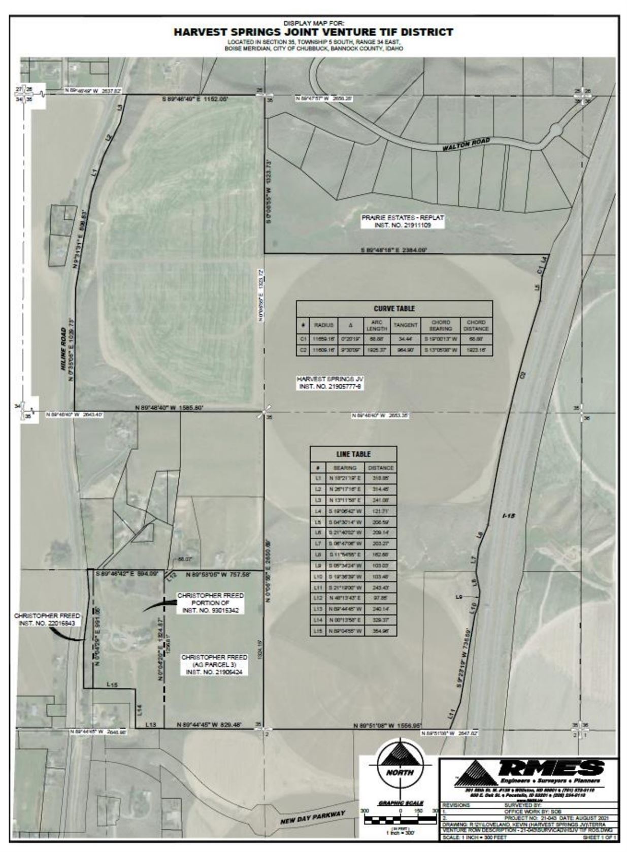
The Urban Renewal Project Area and Revenue Allocation Area herein referred to is described as follows:
An area consisting of approximately 309 acres generally located north of New Day Parkway and west of Interstate 15. It is partially bounded by Hiline Road on the west, Tyhee Road on the north, Interstate 15 on the east and New Day Parkway on the south, and as more particularly described as follows:
A PARCEL OF LOCATED IN SECTION 35, TOWNSHIP 5 SOUTH, RANGE 34 EAST, BOISE MERIDIAN, BANNOCK COUNTY, IDAHO, DESCRIBED MORE PARTICULARLY AS FOLLOWS:
BEGINNING AT THE SOUTH 1/4 CORNER OF SECTION 35; THENCE NORTH 0°06’55” EAST, (BASIS OF BEARING PER THE EAST ZONE OF THE IDAHO STATE PLANE COORDINATE SYSTEM) ALONG THE LONGITUDINAL CENTERLINE OF SECTION 35, A DISTANCE OF 2650.69 FEET TO THE CENTER 1/4 CORNER OF SECTION 35;
THENCE NORTH 89°48’40” WEST, ALONG THE LATITUDINAL CENTERLINE OF SECTION 35, A DISTANCE OF 1585.80 FEET TO A POINT ON THE CENTERLINE OF THE HILINE CANAL;
THENCE FOLLOWING ALONG THE SAID CENTERLINE AS SHOWN ON RECORD OF SURVEY FOR THE ADAMS COMPANY RECORDED AS INSTRUMENT NO. 20900258 IN THE OFFICIAL RECORDS OF BANNOCK COUNTY OVER THE FOLLOWING FIVE (5) COURSES:
- NORTH 0°35’06” EAST A DISTANCE OF 1029.73 FEET;
- NORTH 9°31’31” EAST A DISTANCE OF 808.83 FEET;
- NORTH 18°21’19” EAST A DISTANCE OF 318.85 FEET;
- NORTH 26°17’16” EAST A DISTANCE OF 314.45 FEET;
- NORTH 13°11’58” EAST A DISTANCE OF 241.08 TO A POINT ON THE NORTH LINE OF SAID SECTION 35;
THENCE SOUTH 89°46’49” EAST, ALONG THE NORTH LINE OF SECTION 35, A DISTANCE OF 1152.05 FEET TO THE NORTH 1/4 CORNER OF SECTION 35, SAID POINT BEING A POINT ON THE WEST BOUNDARY LINE OF PRAIRIE ESTATES SUBDIVISION, A SUBDIVISION RECORDED AS INSTRUMENT NO. 20721291 IN THE OFFICIAL RECORDS OF BANNOCK COUNTY;
THENCE FOLLOWING ALONG THE WEST AND SOUTH BOUNDARY LINES OF PRAIRIE ESTATES SUBDIVISION OVER THE FOLLOWING TWO (2) COURSES:
- SOUTH 0°06’55” WEST A DISTANCE OF 1323.73 FEET;
- SOUTH 89°48’18” EAST A DISTANCE OF 2384.09 FEET MORE OR LESS TO THE WEST RIGHT-OF-WAY LINE OF INTERSTATE 15;
THENCE FOLLOWING ALONG THE WEST RIGHT-OF-WAY LINE OF INTERSTATE 15 PER FEDERAL AID PROJECT NOS. I-15-2(3)71 & I-15-2(1)72 OVER THE FOLLOWING EIGHT (8) COURSES:
- SOUTH 19°06’42” WEST A DISTANCE OF 121.71 FEET TO A POINT OF NON-TANGENCY WITH A 11659.16-FOOT-RADIUS CURVE, THE CENTER OF WHICH CENTER BEARS SOUTH 70°49’38” EAST;
- FOLLOWING ALONG SAID CURVE TO THE LEFT THROUGH A CENTRAL ANGLE OF 0°20’19” FOR AN ARC LENGTH OF 68.88 FEET (THE CHORD OF SAID CURVE BEARS SOUTH 19°00’13” WEST A DISTANCE OF 68.88 FEET) TO A POINT OF NON-TANGENCY;
- SOUTH 4°30’14” WEST A DISTANCE OF 208.59 FEET TO A POINT OF NON-TANGENCY WITH A 11609.16-FOOT-RADIUS CURVE, THE CENTER OF WHICH BEARS SOUTH 72°09’48” EAST;
- FOLLOWING ALONG SAID CURVE TO THE LEFT THROUGH A CENTRAL ANGLE OF 9°30’09” FOR AN ARC LENGTH OF 1925.37 FEET (THE CHORD OF SAID CURVE BEARS SOUTH 13°05’08” WEST A DISTANCE OF 1923.16 FEET) TO A POINT OF NON-TANGENCY;
- SOUTH 21°40’02” WEST A DISTANCE OF 209.14 FEET;
- SOUTH 6°47’06” WEST A DISTANCE OF 203.27 FEET;
- SOUTH 11°54’55” EAST A DISTANCE OF 162.68 FEET;
- SOUTH 5°34’24” WEST A DISTANCE OF 103.03 FEET TO A POINT ON THE WESTERLY BOUNDARY LINE OF A PARCEL OF LAND BELONGING TO THE CITY OF CHUBBUCK AS DESCRIBED IN WARRANTY DEED RECORDED AS INSTRUMENT NO. 21813722 IN THE OFFICIAL RECORDS OF BANNOCK COUNTY;
THENCE FOLLOWING ALONG THE WESTERLY BOUNDARY LINES OF SAID PARCEL OF LAND OVER THE FOLLOWING THREE (3) COURSES:
- SOUTH 19°36’39” WEST A DISTANCE OF 103.48 FEET;
- SOUTH 9°23’19” WEST A DISTANCE OF 736.69 FEET;
- SOUTH 21°19’00” WEST A DISTANCE OF 243.43 FEET TO A POINT ON THE SOUTH LINE OF SAID SECTION 35;
THENCE NORTH 89°51’08” WEST, ALONG THE SOUTH LINE OF SECTION 35, A DISTANCE OF 1556.95 FEET TO THE POINT OF BEGINNING.
CONTAINING 267.07 ACRES, MORE OR LESS.
FREED – AGRICULTURAL PARCEL 3 AS SHOWN ON RECORD OF SURVEY FOR ANDREW STODDARD (INST. NO.21900101)
A PARCEL OF LAND LOCATED IN THE SOUTHWEST 1/4 OF SECTION 35, TOWNSHIP 5 SOUTH, RANGE 34 EAST, BOISE MERIDIAN, BANNOCK COUNTY, IDAHO, DESCRIBED AS FOLLOWS:
BEGINNING AT THE SOUTH 1/4 CORNER OF SECTION 35, BEING MONUMENTED BY A 3/4 INCH IRON ROD AS DESCRIBED IN CORNER PERPETUATION RECORDED AS INSTRUMENT NO. 20520350 IN THE OFFICIAL RECORDS OF BANNOCK COUNTY;
THENCE NORTH 89°44’45” WEST, ALONG THE SOUTH LINE OF SECTION 35, A DISTANCE OF 829.48 FEET;
THENCE NORTH 0°04’20” EAST A DISTANCE OF 1256.81 FEET;
THENCE NORTH 48°13’43” EAST A DISTANCE OF 97.85 FEET;
THENCE SOUTH 89°53’05” EAST A DISTANCE OF 757.58 FEET TO A POINT ON THE LONGITUDINAL CENTERLINE OF SECTION 35;
THENCE SOUTH 0°06’55” WEST, ALONG THE LONGITUDINAL CENTERLINE OF SECTION 35, A DISTANCE OF 1324.15 FEET TO THE POINT OF BEGINNING.
SAID PARCEL CONTAINS 25.16 ACRES, MORE OR LESS.
FREED – A PORTION OF THE LANDS DESCRIBED IN WARRANTY DEED GRANTED TO CHRISTOPHER Y. FREED AND JANIE L. FREED (INST. NO. 93015342)
A PORTION OF THE LANDS DESCRIBED IN WARRANTY DEED GRANTED TO CHRISTOPHER Y. FREED AND JANIE L. FREED AS DESCRIBED IN WARRANTY DEED RECORDED UNDER INSTRUMENT NO. 93015342, LOCATED IN THE SOUTHWEST 1/4 OF SECTION 35, TOWNSHIP 5 SOUTH, RANGE 34 EAST, BOISE MERIDIAN, BANNOCK COUNTY, IDAHO, DESCRIBED MORE PARTICULARLY AS FOLLOWS:
COMMENCING AT THE SOUTH 1/4 CORNER OF SECTION 35; THENCE NORTH 89°44’45” WEST, ALONG THE SOUTH LINE OF SECTION 35, A DISTANCE OF 829.48 FEET TO THE POINT OF BEGINNING;
THENCE CONTINUING NORTH 89°44’45” WEST, ALONG THE SOUTH LINE OF SECTION 35, A DISTANCE OF 240.14 FEET; THENCE NORTH 0°13’58” EAST A DISTANCE OF 329.37 FEET; THENCE NORTH 89°04’55” WEST A DISTANCE OF 354.96 FEET; THENCE NORTH 0°04’29” EAST A DISTANCE OF 991.05 FEET; THENCE SOUTH 89°46’42” EAST A DISTANCE OF 594.09 FEET; THENCE SOUTH 0°04’20” WEST A DISTANCE OF 1324.87 FEET TO THE POINT OF BEGINNING.
SAID PARCEL OF LAND CONTAINS 15.37 ACRES, MORE OR LESS.
FREED – THE LANDS DESCRIBED IN QUITCLAIM DEED GRANTED TO CHRISTOPHER FREED (INST. NO. 22016843)
All that portion of the Southwest Quarter of the Southwest Quarter of Section 35, Township 5 South, Range 34 [East], Bannock County, Idaho; lying East of the center line of Hiline Canal and lying adjacent to Deed #93015342. Except that portion East of the Hiline Canal and adjacent to Deed #22001801.
Containing approx. 1.5 acres, more or less.
OVERALL TIF DISTRICT AREA CONTAINS 309.10 ACRES, MORE OR LESS.
**NOTE: EXCEPT AS NOTED OTHERWISE, THE LEGAL DESCRIPTIONS CONTAINED WITHIN THIS DOCUMENT HAVE BEEN PREPARED FROM RECORD INFORMATION ONLY AND NO FIELD SURVEY HAS BEEN CONDUCTED. THIS DOCUMENT IS TO ONLY BE USED FOR A TIF DISTRICT AND NOTHING ELSE**
The Project Area is also depicted in the map
Copies of the proposed Plan are on file for public inspection and copying at the office of the City Clerk, Chubbuck City Hall, at 290 E Linden Ave., Chubbuck, Idaho, 83202 between the hours of 7:30 a.m. to 12:00 p.m. and 1:00 p.m. – 5:30 p.m., Monday through Thursday, and 7:30 a.m. to 11:30 a.m., Fridays, exclusive of holidays. The Plan can also be accessed online at https://cityofchubbuck.us/development-authority/. For additional assistance in obtaining a copy of the Plan in the event of business office interruptions, contact the office of the City Clerk at 208-237-2400, Ext. 201. Costs for copying are outlined by City resolution and Idaho Code Section 74-102.
At the hearing date, time, and place noted above, all persons interested in the above matters may appear and be heard. Because social distancing orders may be in effect at the time of the hearing, written testimony or oral testimony provided virtually is encouraged. Additional information, as well as, information regarding providing testimony in compliance with any social distancing orders in effect may be obtained by calling 208-237-2400, Ext. 201 or by email at jbowers@cityofchubbuck.us.
Council packet will be available upon request to the same email by October 29, 2021. Chubbuck City Hall is accessible to persons with disabilities. All information presented in the hearing shall also be available upon advance request in a form usable by persons with hearing or visual impairments, individuals with other disabilities may receive assistance by contacting the City Clerk, Joey Bowers at jbowers@cityofchubbuck.us at least 24 hours prior to the meeting.
Web-conference (no webcam is necessary to participate)
https://us02web.zoom.us/j/84734247230?pwd=aWN4WnQ3VlNvYXY0Z3J0eTNEU2hMdz09
Meeting ID: 847 3424 7230
Password: 414561
Or to Join by Phone:
+1 669 900 6833 US
DATED: September 15, 2021.
Joey Bowers, City Clerk
Publication date: October 1, 15, 2021.